Publications

Bull14-EN-Cover

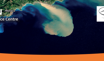
Alex Storm and flash floods in the French Maritime Alps: Spatial imagery for crisis management

SERTIT laboratory explains how they respond to the need for rapid mapping during an event such as the Alex storm that devastated the Alpes-Maritimes at the end of 2020.

23.03.2021

Bull14-EN-Cover

“Working on the democratization of products and services related to spatial imagery and on the creation of synergies between stakeholders for the common good”

Jean Massenet, CEO of Insight SAS and co-facilitator of the GeoDEV New Caledonia RAN, explains his vision of animation and mediation for the promotion of the uses of space. Read also a review of the OSS-NC 2020 event dedicated to New Caledonian satellites.

16.03.2021

Bull14-EN-Cover

SMOS L4RZSM, an operational product dedicated to root zone humidity

Discover or rediscover the Root Zone Moisture product developed at Cesbio from SMOS data for Theia Surface Soil Moisture SEC.

09.03.2021

Bull14-EN-Cover

Just released Theia Bulletin n°14

Read Theia Bulletin n°14 and all the news from the network.

25.02.2021

S2-VarBIO: four biophysical variables to monitor crops and vegetation

The first S2-VarBio demonstration products are now available on Theia.

15.02.2021

GeoDEV: six thematic sheets for users in the South

Theia GeoDEV RAN proposes thematic sheets with Southern users’ needs in mind.

12.01.2021

Transfer, a crucial issue for gaining user confidence, essential to respond collectively to societal challenges of the future

Valérie Demarez, facilitator of Theia Irrigation SEC, gives us her vision of the role of Theia consortium, her SEC and satellite research in the face of today’s challenges.

17.11.2020

Hydroweb counts now over 11000 stations

Hydroweb last version offers data from more than 11000 virtual stations as well as more validation information.

06.11.2020

Land Cover: a Product in Continuous Improvement

Jordi Inglada tells us about the latest developments of Theia Land Cover product.

29.10.2020

Search