Do you know the SCO?
Several projects carried out by Theia Scientific Expertise Centres (SECs) and Regional Animation Network (RANs) have received the SCO label, three small letters that stand for the fight against the impacts of climate change. Founded on 17 June 2019 at the initiative of France, the Space Climate Observatory already brings together 31 space agencies and international organisations. Their objective: to use space data to produce operational tools as soon as possible.
Coastal erosion, marine submersion, collapse of biodiversity, floods, droughts… The birth of the SCO is based on the urgent need to provide decision support tools to territorial managers who must define policies to adapt to the impacts of climate change.
What better input data than spatial information? In this respect, each SCO project combines satellite data with other data sets to operationalise scientific models capable of delivering relevant indicators, early warning systems or short, medium and long-term modelling.
Accelerating the development of operational and replicable tools
The SCO philosophy is based first and foremost on certified projects. They must systematically use spatial data, involve end users, become operational in a maximum of 24 months and be replicable in other places. In order to support the projects and their actors as closely as possible to the field, each SCO signatory country undertakes to set up a local branch.
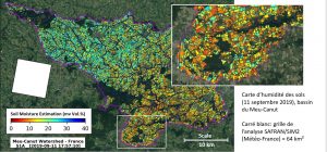
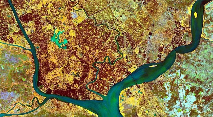
Soil moisture with very high spatial resolution SEC
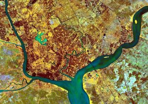
This Sentinel-2 image of the city of Yangon (Myanmar), processed with an NDVI vegetation index, is taken from the operational demonstrator designed to predict environments favourable to leptospirosis in Yangon. This project is based on the work of Theia Risk associated with Infectious Disease Risk SEC. IRD/ Contains modified Copernicus Data
Cascading certification
As the instigator of the initiative, CNES must be a driving force and an example both in the organisation of the national SCO and in the certification process. Following the calls for projects launched in 2019 and 2020, the SCO France is already supporting 37 of the 40 labelled projects. The most represented themes concern agriculture, water management, biodiversity and land use planning.
A strong rise in power
The SCO is expanding more and more each day on all continents. France, China and Mexico have already created their national SCOs, and others are in preparation. Under the status of SCO Acceleration Committees, 4 nations (Gabon, India, Morocco, Thailand) are relying on the need to develop projects presented on their territories to structure their own SCO. All or part of these “balloted” projects will be certified at the 6th International Steering Committee in July 2021. New calls for projects will be launched each year in October.
Attend SCO France quarterly meetings
Thanks to the 22 members of its Inter-Organisational Committee, SCO France is very dynamic. Its Quarterly Meetings are exchange sessions to promote synergy between partners and
projects.
Each session illustrates a theme through 2 to 4 SCO projects which are as many discussion booths. Free registration on the website!
Karol BARTHELEMY
www.spaceclimateobservatory.org
Contacts SCO :
laurence.Monnoyer-Smith@cnes.fr
Frederic.Bretar@cnes.fr