Data access
Presentation

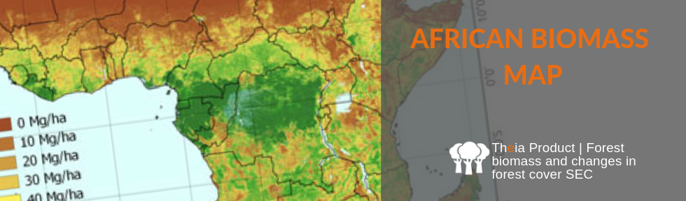
This dataset gives estimates of the woody above-ground biomass (AGB) of the savannahs and woodlands of continental Africa and Madagascar at a resolution of 50m x 50m, obtained through a bayesian inversion of an L-band SAR mosaic from ALOS PALSAR (HH and HV polarizations), with the help of 144 reference plots.
AGB is estimated between 0 and 85 Mg.ha-1, and dense forests, flooded forest, mangroves, urban areas and water bodies are masked out using the ESA CCI Land Cover.
Authors : Alexandre Bouvet (CESBIO), Stéphane Mermoz (CESBIO), Thuy Le Toan (CESBIO), Ludovic Villard (CESBIO), Renaud Mathieu (CISR), Laven Naidoo (CISR), Gregory P. Asner (Carnegie Institution for Science)
Acknowledgements : JAXA for the provision of PALSAR mosaics, ESA for the provision of the CCI Land Cover and funding the GlobBiomass project, Cnes (Tosca), the European Union (H2020, EOMonDis project).
References : Bouvet A., Mermoz S., Le Toan T., Villard L., Mathieu R., Naidoo L., Asner G. P., 2018. An above-ground biomass map of African savannahs and woodlands at 25 m resolution derived from ALOS PALSAR. Remote Sensing of Environment, vol. 206, pp. 156-173, doi: 10.1016/j.rse.2017.12.030
Contact

Alexandre Bouvet
Cesbio
@A.Bouvet
Format
Metadata
GeoTIFF raster (compression LZW)
EPSG: 4326
Resolution: 1.6 arcseconds x 1.6 arcseconds (environ 50m x 50m à l’équateur)
Pixel type: byte (8 bits)
Dates of the data
PALSAR: 2010
CCI Land Cover: 2010
Field data : 2010 ± 2,5 ans (2006-2012)
All Biomass Products
Products
African Biomass Map
Products
Biomass for French Guiana
Products
Biomass for Madagascar
Products