Data access
Presentation

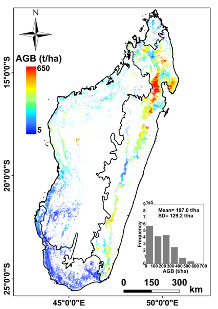
This biomass map has a spatial resolution of 250m x 250m and was obtained using the data fusion of LiDAR, optical and other climatic datasets. The precision of the map by comparison to field estimates is around 74 Mg/ha.
Authors: Mohammad El Hajj (Irstea), Nicolas Baghdadi (Irstea), Ibrahim Fayad (Irstea), Ghislain Vieilledent (JRC, Cirad), Jean-Stéphane Bailly (AgroParisTech), Dinh Ho Tong Minh (Irstea)
Thanks to: Irstea, Cnes (Tosca), Cirad (projet BioSceneMada), JRC (projet ReCaREDD), établissements malgaches (DGF, ONE, WWF, CI, WCS, Goodplanet/ETC Terra), NSDIC (National Snow and Ice Data Center) pour la mise à disposition des données lidar ICESat/GLAS.
References: El Hajj M., Baghdadi N., Fayad I., Vieilledent G., Bailly J.S., Ho Tong Minh D., 2017. Interest of integrating spaceborne LiDAR data to derive accurate biomass estimates in high biomass forested areas. Remote Sensing, 9(3), 213, pp. 1-19, doi: 10.3390/rs9030213.
Contact

Nicolas Baghdadi
INRAE | Tetis
ResearchGate
Contributions
Format
Metadata
GeoTIFF raster
NoData: -3,40282306074e+038
EPSG: 32738
Resolution: 250 m
Pixel type: double precision (32 bits)
Data years
ICESat: 2003-2009
Optical data : 2000-2010
SRTM: 2000
Field inventories : 1995-2013
References
El Hajj M., Baghdadi N., Fayad I., Vieilledent G., Bailly J.S., Ho Tong Minh D., 2017. Interest of integrating spaceborne LiDAR data to derive accurate biomass estimates in high biomass forested areas. Remote Sensing, 9(3), 213, pp. 1-19, https://doi.org/10.3390/rs9030213.
Forest biomass map in Madagascar : El Hajj, M., Baghdadi, N., Fayad, I., Vieilledent, G., Bailly, J.-S., & Ho Tong Minh, D. (2018). Forest biomass map in Madagascar. Irstea. https://doi.org/10.17180/forest-biomass-map-madagascar-2017


