VENUS: Call for site proposals for daily observations

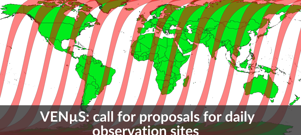
From November 2021 on and for at least one year, the French-Israeli VENµS Earth observation satellite launched in 2017 will enter a new phasis. It will ten acquire every day images with a resolution of 4m in 12 spectral bands for the scientific community.

A very open call

The call for proposals launched today aims to select the sites that will be observed. The deadline for proposals is 15 February 2021.

The call is open to researchers from educational institutions, research institutes, government institutions, non-profit organizations, and to any type of organization, including private and commercial companies, provided they conform to the CC BY-NC 4.0 license of the data (no commercial use).

Although VENμS mission was primarily designed for vegetation studies, the results of the first phase show that VENμS is also useful for a range of topics, such as water quality, glacier movements, coastal erosion monitoring, and the atmosphere. Therefore, the proposals will not be restricted to any research topic.

Download the call for proposals

Contact

Gérard Dedieu
Cesbio
@G.Dedieu

Previous news from VENµS

Two THEIA LiDAR tools for forest monitoring

On this International Day of Forests, for which innovation has a major role to play in 2024, we are highlighting two tools dedicated to the management of aerial LiDAR data […]

SWOT data that exceeds expectations

The SWOT space mission was launched at the end of 2022 by CNES and NASA to document the water masses of the entire planet – oceans and continental waters. Data […]

OSO 2023 Data : a little more patience ahead

THEIA Land Cover product is produced each year by CESBIO and CNES. It provides a 24-class typology of land cover, downloadable by department for mainland France. Production begins in January […]

MAJA is already ready for CAMS

From the end of September, the MAJA processing chain will be using CAMS 48r1 data for the production of Theia Surface Reflectance products.

Land cover Theia product update

Like every year at this time, you’re invited to discover the new version of the OSO product, from the S.E.C Land cover. The 2022 version was released a few days […]

MAJA ADAPTS TO CAMS’ EVOLUTION

The development of CAMS aerosol products requires MAJA to be adapted and has an impact on the production of Reflectance Theia products.

[Just Released] Theia Bulletin N°16

>>>News from the network: Nomination of Anne Puissant as Theia new Scientific Director; Theia workshop on irrigated areas; Trishna Days ; GAIA Data and Terra Forma Kick-Offs, Critical Zone Award, […]

FOTOTEX: An Unsupervised Method for Urban Areas

FOTOTEX, developed within Theia Risks Associated with Infectious Disease Risks and Urban SECs, proposes a unique, rapid and unsupervised method for characterising urban areas at three overlapping scales.

Do you know the SCO?

The SCO facilitators discuss the Space Climate Observatory project, through which several THEIA SECs and RANs projects have been labelled.

MACLEAN2020 Call for paper

Submit now your paper on Machine Learning for the MACLEAN 2020 event in Ghent in conjunction with ECMLPKDD

OTB 7.0

Orfeo ToolBox 7.0 is available for download. Discover new applications, fixed bugs, and python bindings even more convenient to use!

Call for Speakers |4th conférence DRONE Berlin

Call for speakers now open for the 4th DRONE Berlin Expo & Conference 2020. Topics of interest include drone design and manufacturing, functional components and software.  A special track on […]

Focus on Theia Snow Product

❄️❄️Focus on Theia Snow Product confronting the point of view of the end-users and the researcher.

8 positions to be filled at Mohammed VI University

Mohammed VI University (Morocco) is opening 8 new positions as lecturers on environmental issues. No nationality requirement. Descriptions and conditions on ResearchGate https://www.researchgate.net/job/929259_Assistant_Professor_position_in_Operational_Water_Resources_Engineeringhttps://www.researchgate.net/job/929070_Assistant_Professor-Remote_Sensing_application_to_natural_resources_management?https://www.researchgate.net/job/929265_Assistant_Professor_position_in_Waste_Water_Treatment_Technologies?https://www.researchgate.net/job/929260_Assistant_Professor_position_in_Climate_change_impact_on_water_resources_and_crop_production_in_Africahttps://www.researchgate.net/job/929264_Assistant_Professor_Position_in_Integrated_Water_Resources_Managementhttps://www.researchgate.net/job/929263_Assistant_Professor_Water_Economyhttps://www.researchgate.net/job/929261_Assistant_Professor_position_in_Space_Hydrologyhttps://www.researchgate.net/job/929262_Assistant_Professor_position_in_Water_Desalination_Technologies?

Drying-up of Aculeo Lake (Chile)

Using Sentinel-2 data the SERTIT team documented the gradual disappearance of Lake Aculeo, near Santiago, Chile, between February 2016 and March 2019.

World-leading scientists sought for Earth Commission

Future Earth is seeking nominations for members of the Earth Commission. The Commissioners will provide the scientific insights needed to underpin the setting of science-based targets for a stable and […]

Four months without any cloud above France

Theia Surface reflectance SEC and Cnes keep on with the monthly production of Sentinel-2 L3A composites without cloud for the French territory. Data are now available for July, August, September, and October 2018, allowing observers to […]

A Cloudless Belgium

Using the new L3A product in Theia it is possible to make nice cloud-free mosaics from Sentinel-2 imagery.

Sentinel-2 Data for Lebanon and Telangana

The MUSCATE team has added two new zones where Sentinel2 data are processed to Level 2A (cloud mask and atmospheric correction) with MAJA processor: Lebanon and Telangana region in India.

Theia French-Iranian Summer School

From July the 7th to July 10th 2018 thez first Theia Franch-Iranien Summer School has convened hosted by the Geomatics Engineering Faculty at the K. N. Toosi University, Tehran (Iran).

Over 10’000 snow products in Theia

To celebrate the 10’000th snow product in Theia, here is over the Vicdessos area in the french Pyrenees near Andorra. The snow is in blue and the clouds are in white!

Theia Downtime on July 25th and 26th 2018

Due to a major evolution of the CNES Cluster infrastructure, the CNES servers of Theia won’t be available from July 25th 9h to July 26th 20h.More information: Data access

Theia 9th bulletin

The Theia Land Data Services Centre new bulletin is available in English.

First delivery of Venµs images

A set of 35 images (L1C) acquired over the Venµs sites since January 2018 are available for download on the following Cnes web site theia.cnes.fr

Sentinel-2 technical solutions survey

In order to ease the data access of Sentinel2 reflectance tiles, Theia wishes to collect users opinion on the utility of different technical solutions.

QGIS in Remote Sensing

Series of books on QGIS in remote sensing has just been published with ISTE-Elsevier editions.

Theia 8th bulletin

The Theia Land Data Services Centre new bulletin is available in English.

WHISPERS 2018 in Netherlands

The 9th Workshop on Hyperspectral Image and Signal Processing : Evolution in Remote Sensing (WHISPERS) will be held in Amsterdam, Netherlands, September 23-26 2018.

Geobia’18 in France

The 7th edition of Geobia, the Geographic Object-Based Image Analysis, will take place in Montpellier (south of France) the 19 to the 23 of June.

MOOC on Radar Remote Sensing

ESA opens the first Massive Open Online Course on Radar Remote Sensing, « Echoes in Space », starting on 9 October 2017.

Venµs satellite first images

A few days after being placed into orbit, the French-Israeli Venµs vegetation-monitoring satellite delivered its first images.

New Sentinel 2 data over Europe

Sentinel-2 data acquired from December 2016 and processed at level 2A are now available above Italy, Switzerland and Austrian Alps.

Sentinel-2 : all sites available

All the sites that had been selected by Theia for the production of Sentinel-2 Level 2A products are now in production within Muscate.

More than 20 000 Sentinel-2 products

The number of Sentinel-2A Level2A products just passed the 20000 milestone, with the complete collection of French oversea regions, and new sites along the Ganges, Brahmaputra and Mekong rivers.

Swot mission : campaign in the Seine

A campaign is taking place on 22 and 23 June 2017 in the lower Seine valley with different sensors using several techniques to prepare Swot data validation in the future.

Thematic School: remote sensing and biodiversity

The Labex CEBA is organising its thematic school on remote sensing and its potential uses in the study of biodiversity. It will be held at the Hotel des Roches in Kourou (French Guiana) as from the 25th to the 29th of September 2017.

New Landsat 8 products (March 2017)

The Theia Muscate production center distributes new level 2A Landsat 8 products acquired from March 1st to 31th 2017 in France and in the French overseas territories.

Remote sensing methods to monitor tropical forests

« Sourcebook of Methods and Procedures for Monitoring Essential Biodiversity Variables in Tropical Forests with Remote Sensing » published by Global Observation of Forest Cover and Land Dynamics (GOFC-GOLD) is available for download.

Near real time production for Sentinel-2 L2A

The production of Sentinel-2 L2A products nears real time, and L2A products acquired until March 2017 over France and Reunion Island have started to appear on the distribution server.

New Sentinel-2A data over Morocco

One year of Sentinel-2A data at Level 2A above a large region of Morocco, from Ouarzazate to Casablanca, are available from theia.cnes.fr.

Sentinel-2B delivers its first images

Just over a week after being lofted into orbit, the European Union’s Sentinel-2B satellite delivered its first images of Earth, offering a glimpse of the ‘colour vision’ it will provide for the Copernicus environmental monitoring programme.

Wildfire Remote Sensing Workshop

A workshop on the Role of Remote Sensing in Wildfire Management and Research will be held from 20th to 22th 2017 of June in Montreal (Canada).

5000+ L2A Sentinel-2A products available

CNES just released large time series of Sentinel-2A L2A data, over France, Reunion Island, North of Spain, Belgium, Luxembourg, and on some large sites in Burkina Faso, Mali, Ethiopia, and Tunisia.

Sentinel-2B satellite launch

The ESA-developed Sentinel-2B satellite was launched on 7 March 2017, doubling the coverage of high-resolution optical imaging in the Sentinel-2 mission for the European Union Copernicus environmental monitoring system.

New Landsat 8 products (January 2017)

The Theia Muscate production center distributes new level 2A Landsat 8 products acquired from January 1st to 31th 2017 in France and in the French overseas territories.

COAST Bordeaux 2017

The COAST Bordeaux 2017, international symposium and Forum on maritime and coastal areas, will be held from 6th to 10th of November 2017 in Bordeaux.

New Landsat 8 products (December 2016)

The Theia Muscate production center distributes new level 2A Landsat 8 products acquired from December 1st to 31th 2016 in France and in the French overseas territories.

New Landsat 8 products (October 2016)

The Theia Muscate production center distributes new level 2A Landsat 8 products acquired from November 1st to 30th 2016 in France and in the French overseas territorie.

New Landsat 8 products (October 2016)

The Theia Muscate production center distributes new level 2A Landsat 8 products acquired from October 1st to 31th 2016 in France and in the French overseas territorie.

New Landsat 8 products (September 2016)

The Theia Muscate production center distributes new level 2A Landsat 8 products acquired from September 1st to 31th 2016 in France and in the French overseas territorie.

Land Surface Remote Sensing in 6 volumes

Series of books on remote sensing applied to continental surfaces has just been published with ISTE-Elsevier editors entitled “Land Surface Remote Sensing”.

New Landsat 8 products (August 2016)

The Theia Muscate production center distributes new level 2A Landsat 8 products acquired from August 1st to 31th 2016 in France and in the French overseas territorie.

2nd Global Soil Security Conference

The 2nd Global Soil Security Conference entitled «More Science-Society interfaces for a global soil security » will take place in Paris December 5th and 6th 2016.

New Landsat 8 products (July 2016)

The Theia Muscate production center distributes new level 2A Landsat 8 products acquired from July 1st to 31th 2016 in France and in the French overseas territorie.

New Landsat 8 products (June 2016)

The Theia Muscate production center distributes new level 2A Landsat 8 products acquired from June 1st to 30th 2016 in France and in the French overseas territorie.

Orfeo Toolbox User Days 2016

Orfeo Toolbox team is happy to announce the second edition of the OTB User Days to be held from 7 to 9 June 2016 in Toulouse.

New Landsat 8 products

The Theia Muscate production center distributes new level 2A Landsat 8 products acquired from November 16 to 30th 2015 over France.

First prototype land cover map

The Scientific Expertise Center on Land Cover provides its first prototype products, land cover Maps automatically generated.

Sentinel-2A products available

ESA is pleased to announce the availability of Sentinel-2A orthorectified products acquired from 28 November onward are available to any user.

New Landsat 8 products

The Theia Muscate production center distributes new level 2A Landsat 8 products acquired from October 1 st to 15th 2015 over France.

WHISPERS 2016 in California

The 8th Workshop on Hyperspectral Image and Signal Processing : Evolution in Remote Sensing (WHISPERS) will be held in Los Angeles, California, august 21-24 2016.

New Earth Explorer 9 call

As part of its Earth Observation Envelope Programme, the European Space Agency (ESA) announces an opportunity for scientists from the Earth Observation communities, to make proposals to be assessed as potential Earth Explorer Mission.

New Landsat 8 products

The Theia Muscate production center distributes new N2A Landsat 8 products acquired from October to 30th 2015 over France.

ITISE 2016 : call for paper

The International Work-Conference on Time Series (ITISE 2016), which will take place in Granada (Spain) in June, 2016, solicits high-quality original research papers until December 11th 2015.

New Landsat 8 products

The Theia Muscate production center distributes new N2A Landsat 8 products acquired from September16th to 30th 2015 over France.

New Landsat 8 products

The Theia Muscate production center distributes new N2A Landsat 8 products acquired from September 1st to 15th 2015 over France.

STUDENT POSTER COMPETITION

In the framework of the ISPRS Geospatial Week of La Grande Motte (28 Sept – 2 Oct 2015) , in order to let young researchers discover a scientific conference by presenting their first works and in order to favor their hatching in their community, a student poster competition is now open

Release of SPOT5-Take5 data

ESA and CNES just announced that the data from the SPOT (Take5) experiment acquired until the 3rd of June have been released.

1st Remote Sensing Data Infrastructures workshop

The Theia Land Data Centre and the Geosud Project organize the first “Remote Sensing Data Infrastructure for land application services” workshop the 1st of October as a side event of the ISPRS Geospatial Week 2015, La Grande Motte, France.

New Landsat 8 products

The Theia Muscate production center distributes every 2 weeks new Landsat 8 products acquired in 2015 over France.

First Spot 5 (Take5) Ortho

The first Spot 5 (Take5) image from the Lake Victoria image in Uganda has been ortho-rectified (L1C).

New Landsat 8 products

The Theia Muscate production center distributes 76 new Landsat 8 products acquired from March 16th to March 31h 2015 over France.

New Landsat 8 products

The Theia Muscate production center distributes 98 new Landsat 8 products acquired from March 1st to March 15th 2015 over France.

New Landsat 8 products

The Theia Muscate production center distributes 63 new Landsat 8 products acquired from February 16th to February 28th 2015 over France.

New Landsat 8 products

The Theia Muscate production center distributes 66 new Landsat 8 products acquired from February 1st to February 15th 2015 over France.

Climate change conference

The International Scientific Conference “Our Common Future under Climate Change” will take place at UNESCO (Paris) in July 2015.

Orfeo ToolBox new version

The 4.4 version of Orfeo ToolBox (OTB), an open-source C++ library for remote sensing images processing (Cnes), has been released.

Remote sensing of soils report

The “Remote Sensing of Soils” report project initiated by the Federal Office of the Environment (FOEN/BAFU) released.

Venus call

Announcement of Opportunity Call for proposals of sites for the Venµs Earth Observation Mission CNES, the French space agency, and ISA, the Israel space agency, are soliciting research proposals for […]

Theia-Geosud Seminar

The Theia Land Data Centre and Equipex Geosud are organising their first joint seminar on the theme «Space Data for the scientific community and public stakeholders», on 1 and 2 June 2015 in Montpellier.

EnvisionsGEOMATICS in Québec

Le Centre de géomatique du Québec organises the 4th edition of EnvisionGeomatics seminar on 12th and 13 november 2014 in Gatineau (Québec).

FORESEE Workshop

The Workshop FORESEE “Forestry applications of remote sensing technologies” will be held from 8 to 10 October 2014 in Nancy (France).

IEEE call for papers

Call for paper for two IEEE publications, Journal of Selected Topics in Applied Earth Observations and Remote Sensing (JSTARS) and Journal of Selected Topics in Signal Processing (JSTSP).

ESA Lidar tender

ESA open invitations to tender on ” Compressive sensing technologies for compact LiDAR systems – Expro Plus »

Launch of SPOT 7

The SPOT 7 Earth-observation satellite, designed and developed by Airbus Defence and Space, was launched successfully on 30 june 2014 from the space centre in India.

ALOS-2 launched

Advanced Land Observing Satellite-2 (ALOS-2), also called Daichi-2, from Jaxa Japan Aerospace Exploration Agence was launched on 24 may 2014.

The Greenland ice sheet is darkening

Researchers from CNRM-GAME and LGGE has shown thanks to satellite observations that Greenland ice sheet in springtime is less « white» since 2009.

SMOS Science Conference

CESBIO organise with ESA the conference “Understanding the Carbon and Water Cycles using SMOS data and models” on 13 and 14 november 2014 in Toulouse (France).

Deimos-2 launched

Deimos-2 was launched on 19th June, and reach orbit successfully.

EgyptSat-2 launched

The Egyptsat-2 satellite was launched on 16th April 2014 by a Soyuz-U from Baïkonour Cosmodrome.

News about the Spot World Heritage Programme

The programme objective is the free availability for non-commercial use of orthorectified products derived from multispectral images of more than 5 years old from the Spot 1-5 satellites family.

More news

A new GeoDEV website, with resources tailored to your profile

The website of the ART GeoDEV, the Theia Regional Animation network that CIRAD, IRD and CNES have been leading since 2017 in the direction of Southern countries, is evolving to […]

Exemple de traitement Arbocarto pour Mayotte, avril 2023

May 2023, Montpellier | Arbocarto user meetings

Three days of workshops for users of the Arbocarto tool were organised in Montpellier and in “hybrid” mode, from 9 to 12 May 2023. These days were organised in hybrid […]

April 23-28, 2023 | Data Terra and Theia at EGU

The General Assembly of the EGU 2023, gathering all the scientists of the life of the Earth, will be held in Vienna (Austria) from April 23 to 28. DATA TERRA’s […]

Search